
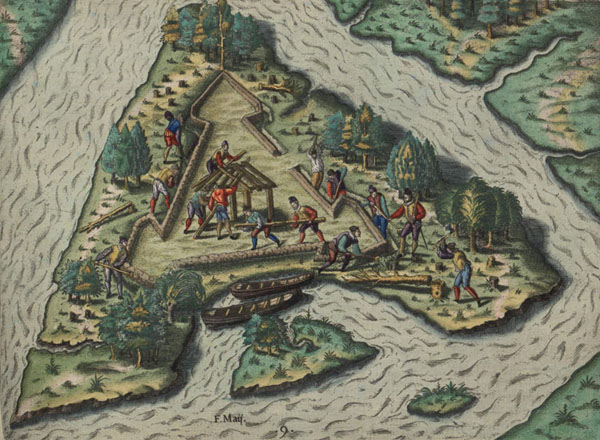
Fort Caroline was built by the French in 1564 on the banks of the River of May, the present-day St. Johns River in Jacksonville, Florida. Its exact location has never been found.
One of our archaeologists, Brian McNamara, visited Fort Caroline yesterday. He was one of the first to hear of a potential new discovery. State Representative Lake Ray and his son Lake Ray IV made the announcement yesterday that they believe they have identified the exact location of Fort Caroline, on the St. Johns River in the Timucuan Preserve, a National Park Service property that also includes the Fort Caroline National Monument.
From the Florida Times-Union:
The nearly 450-year-old site of North America’s first French colony is on a small island between Mayport and Buck Island, state Rep. Lake Ray said Tuesday…
Ray said he’s confident the Jacksonville site is the real location of Fort Caroline. He asked that the location of the site not be disclosed to protect it from looters. The site is being protected by the Coast Guard and National Park Service, he said.
Finding the original site of Fort Caroline has been a hundreds-year-old mystery that Northeast Florida historians have long since tried to solve.
The French established the fort in 1564. Spanish soldiers from St. Augustine later attacked it and ultimately the French abandoned it.Ray’s son, Lake Ray IV, has searched for the site of Fort Caroline since 2010.
Ray IV, who has a bachelor’s in history from the University of North Florida, brought his father in on the search about two months ago, and they used copies of maps they inherited from the state representative’s father.
Within those maps, they said, they found an original drawing of Fort Caroline, penned by a young man who sent the map back home to his father. They used geological survey maps from the early 1900s and found a small island that matched the map, Rep. Ray said.
He said moats that were known to have bordered the site are clearly visible on the land, and there’s an imprint of a triangular structure that was part of the fort and rectangular courtyard.“If you get out on the island, there’s no doubt,” said Ray IV.
University of North Florida associate professor of anthropology Robert “Buzz” Thunen said researchers will need to find French and Spanish artifacts before the site can be verified.
No excavations have begun yet, but they may start within three weeks after researchers get the proper permits, Thunen said.
Barbara Goodman, National Park Service superintendent for the Timucuan Ecological and Historic Preserve and the Fort Caroline National Memorial, said archeologists will start by digging 10 or 12 test holes. From there, researchers will determine whether there’s enough cause to continue excavations.
“Its a felony for anyone who isn’t authorized to go digging around on the property,” she said. “As soon as we have some information to share, we’ll share it. Until we know what we have, we need to keep the site protected.”
She said research will start as soon as certain details, such as funding for the dig, can be settled.
NPR and First Coast News also ran stories on the potential discovery.
They used aerial photographs to identify landforms that might correspond to the remains of the original fort and its moat. At this stage I would say their finds are preliminary in nature, and would need to be tested archaeologically before we could say with any confidence that they represent the actual site of the fort. They supposedly have artifacts from the site, which I have not seen (and which would be illegal to have removed from the site without a National Park Service permit), that when analyzed by archaeologists might also lend credit to their claim. Regardless, there is excitement in the air about Ribault, Fort Caroline, and the Lost French Fleet this year, the 450th anniversary of the French settlement!